
Executive Summary
In many developing and emerging countries, it can be difficult to access and collect on-site data due to many unavoidable reasons like cost, time, legal causes, language barrier or low availability of the data. The Global Information Systems (GIS)-based planning and decision support tool ALLOWS (Assessment of Local Lowest-cost Wastewater Management Solution) adapts to this condition of data scarcity by incorporating remote data (e.g., satellite data) for planning and developing different wastewater management scenarios at a regional scale. Within the PAVITR project, the main objectives were to test and further develop the ALLOWS tool by i) adapting it to data scarcity and ii) applying it to a regional scale near Aligarh in the Indian state of Uttar Pradesh (UP).
Background
Planners and decision makers in the water sector often face challenges to identify adequate development strategies and suitable financing schemes for wastewater infrastructure. It is mainly due to a lack of i) available data, ii) proper data management (no connection between different entities with different databases), iii) support in decision making (e.g.: technology selection) and iv) knowledge of the costs associated with selected management options (wastewater collection, transport, treatment, and reuse). Within this context, a GIS-based preliminary planning and decision support tool was developed by the Helmholtz Centre for Environmental Research (UFZ) to identify cost-effective local wastewater management solutions for any given demographic and physical context (van Afferden et al. 2015).
The ALLOWS tool provides an integrated analysis of the current situation, assists in the development of technical solutions (scenarios), and provides associated costs and cost comparison among different scenarios. This enables local, regional, and national administrations to plan for future development and to focus their dialog with international financing organizations (e.g., World Bank, the German Reconstruction Credit Institute (KfW), the Asian Development Bank (ADB), the Bill & Melinda Gates Foundation, etc.).
One of the main challenges for such a decision support tool to be applied in India is related to limited availability of data the ALLOWS tool would require as input. Therefore, as part of the PAVITR project, testing and further development activities of the ALLOWS tool were carried out by creating a database using remote data (e.g. satellite data) and validating it with locally available data. The acquired database was then used to produce, evaluate, and compare realistic water and sanitation management scenarios on technical and economic levels and to provide recommendations to local stakeholders for planning at regional scale.
What the ALLOWS tool is about
The ALLOWS approach and methodology
The ALLOWS approach consists of three general components as illustrated in Figure 1 below; (1) Compilation of Database, (2) Spatial Analysis, and (3) Cost Assessment.
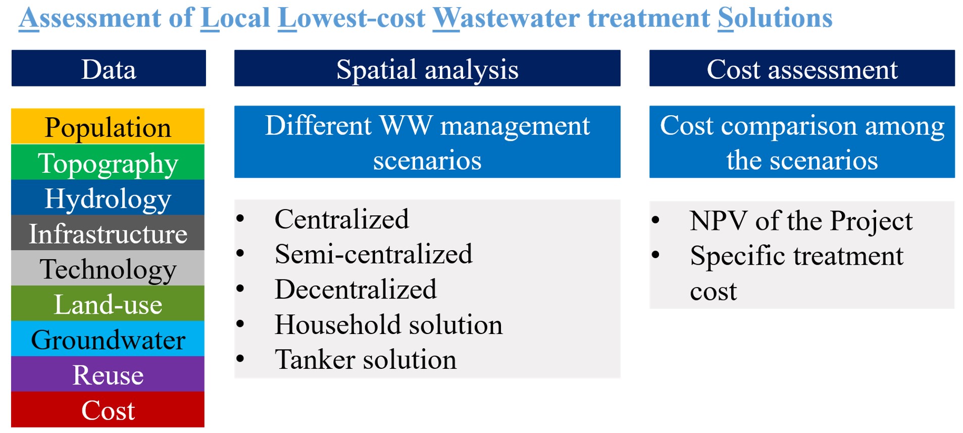
Figure 1. Flowchart showing ALLOWS approach and general components. Source: VAN AFFERDEN et al. (2015)
The first component is about the compilation of a database, whose data are aggregated and processed in order to prepare wastewater management scenarios. The scenarios defined in the data processing step can then be analysed and compared.
The second component, the spatial analysis, enables high precision assessment of the current wastewater situation and facilitates the development of possible management scenarios under real conditions. The scenario development relies on the results of the GIS analysis considering hydrology, terrain, groundwater vulnerability, household connection degree, existing infrastructure, population density, and population forecast. Depending on the site-specific characteristics of a settlement, several wastewater management scenarios (centralised, semi-centralised or clustered, decentralised etc.) are elaborated.
In the third component, the economic assessment, technical data including the length of the proposed sewer network and the capacity of the wastewater treatment plant lay the foundation for the economic assessment of the scenarios. The Dynamic Cost Comparison Calculation (DCCC) method delivers the Net Present Value (NPV) for each scenario using local and global cost benchmark data, and thus facilitating the decision-making process to select the best-suited and most cost-efficient solution also in terms of potential investment in local wastewater infrastructure.
Experiences Globally
Since the ALLOWS tool was developed, it has been successfully applied globally to several settlements with ranging population sizes from small rural localities to cities.
For example, in Jordan, the ALLOWS tool was applied to visualize temporal and spatial predictions of population growth for different types of settlements. The tool confirmed semi-centralised and decentralised wastewater management solutions as the more suitable approach for rural areas (Ira and Yarka) and a combination of decentralised and centralised solutions as the more suitable approach for the fast-growing urban area of Al-Salt City (VAN AFFERDEN et al. 2010).
In Al Mazarih, Oman, the ALLOWS tool application revealed a strong case for decentralised wastewater management approaches instead of centralised solutions. The decentralised and semi-centralised scenarios might also become attractive under the assumption that the town will increase in population at high rate (Khurelbaatar et al. 2021).
In China, the ALLOWS tool was applied under Chinese conditions, resulting in the proposition of decentralised wastewater management as an approach to limit the pollution of Lake Chaohu (area covering 200 km2) (AUBRON et al. 2019).
The challenges we face include the lack of data availability, analysis and scenario development for regions covering a vast area, and the process of planning the wastewater management scenarios. The lack of local data led the tool to be adapted to the use of globally available open-source data, which is an integral part within the frame of PAVITR project. The development of region-wide or even nationwide wastewater management scenarios is a challenge to be addressed, as it already contains the low data availability challenge within itself. Although many tools are used to roughly estimate the costs associated with the wastewater management in some region, the intention of ALLOWS tool is to be used as preliminary planning and decision support tool, meaning that the region of interest to be analysed and real scenarios to be developed. Some of the aspects of this challenge are tackled within PAVITR project, such as identification of optimal cost solution for the study area, which comprises 184 villages and an area of 400 km².
Among the most promising potential users of ALLOWS tool are consultants, planners and stakeholders that are involved in various water and sanitation management projects. For the replication and dissemination by using ALLOWS, an operation manual or a training script is handed over to the local partners/stakeholders as a user guideline.
Experiences in India
There is currently a growing demand for the improvement of overall sanitation conditions in India. However, proper planning and decision-making processes are inhibited by many factors including limited data availability. Most challenging is the access to and availability of accurate regional data as the local stakeholders are quite often unable to identify and/or provide data useful for the planning of wastewater management infrastructure (for e.g., population, topography, daily water consumptions, existing infrastructure, etc.). However, the experiences in India with the application of such planning tool, and ALLOWS specifically, are limited.
Within the PAVITR project, a large area in the district of Aligarh, UP, India (area covering 400 km2) was used for testing, adaptation, and further development of ALLOWS tool at regional scale. The selected area has a precarious sanitation situation, including an absence of local policies for the provision of water and sanitation infrastructure to non-served areas and therefore is a priority area for local Indian government and international funding agencies.
This study provides the insight into the extent to which level of centralisation and decentralisation for wastewater management is suitable and how the scenarios would look like in terms of sizing, layout, and costs. The achieved results contribute to the planning for wastewater management projects not only in India but also in the whole region. For further information, please follow the latest publications, Khurelbaatar et al. (2024), in the reference list and contact with the project partner at the Helmholtz Center for Environmental Research (UFZ), Leipzig, Germany.
WP-B: Development and Testing of a GIS-Based Planning Tool for Creating Decentralized Sanitation Scenarios
Data Reduced Method for Cost Comparison of Wastewater Management Scenarios-Case Study for Two Settlements in Jordan and Oman
Preliminary planning and optimization tool for wastewater infrastructure for regions with low data availability
A step towards decentralised wastewater management in the Lower Jordan Rift Valley
Chinese Water Systems. Volume 2: Managing Water Resources for Urban Catchments: Chaohu
This book presents comprehensive results of a Sino-German joint project on water resources in East China and discusses state-of-the-art water resources and water quality management in the Chao Lake Catchment. It contains hydrological and groundwater models, scenario analysis, software tools, equipment solutions for urban water management. In Chapter 4, there is a comprehensive discussion on GIS-based ALLOWS tool to create and evaluate decentralised wastewater management scenarios comparing on a cost-efficiency basis in order to point stakeholders towards appropriate wastewater management solutions.
SACHSE, A., LIAO, Z., HU, W., DAI, X. and KOLDITZ, O. (Eds.) (2019): Chinese Water Systems. Volume 2: Managing Water Resources for Urban Catchments: Chaohu. Switzerland: Springer Nature Switzerland: URL [Accessed: 30.05.2023] PDFIntegrated Water Resources Management in the Lower Jordan Valley Sustainable Management of Available Water Resources with Innovative Technologies - Management of Highly Variable Water Resources in semi-arid Regions SMART-MOVE
Sustainable Management of Available Water Resources with Innovative Technologies - Management of Highly Variable Water Resources in Semi-Arid Regions (SMART-MOVE) is the follow-up and implementation phase of the preceding SMART I and II projects, which aimed at developing a transferable approach for Integrated Water Resources Management (IWRM) in the Lower Jordan Valley. The objective of one of the work packages was the application of the GIS-based ALLOWS tool to identify potential wastewater management solutions and to provide associated cost indicators for the solutions in the Al-Salt region.
LANGE, T., RUSTEBERG, B., SAUTER, M., ALMANASEER, N., VOGEL, K. (2019): Integrated Water Resources Management in the Lower Jordan Valley Sustainable Management of Available Water Resources with Innovative Technologies - Management of Highly Variable Water Resources in semi-arid Regions SMART-MOVE. In: Final Report -SMART-Phase III URL [Accessed: 30.05.2023]New decision support tool to assist wastewater management in Drin basin
This website illustrates new decision support tool to assist wastewater management in Drin basin. The new Wastewater Management Decision Support Tool (WEMDST), a pilot within the GEF Drin Project, will help local planners identify environmentally efficient and cost-efficient solutions.
https://www.gwp.org/en/GWP-Mediterranean/WE-ACT/News-List-Page/WEMDST-consultation/ [Accessed: 30.05.2023]