المُلخص التنفيذي
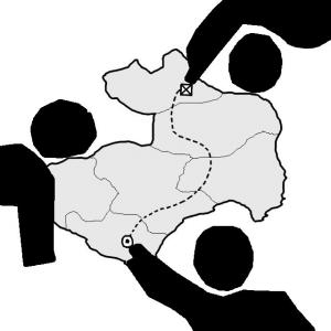
Participatory Mapping, a method used within Participatory Rural Appraisal (PRA) is used in participatory research as well as in planning and management initiatives for development activities on a local level. In its broadest sense, participatory mapping means the creation of maps by local communities – often with the involvement of supporting organisations including governments, NGOs or other actors engaged in development or land-related planning. Participatory maps provide a valuable visible representation of what a community perceives as its place and the significant features within it. The process of mapping can contribute to building community cohesion, help to engage participants to be involved in resource and land-related decision-making, raising awareness about pressing land-related issues and ultimately contribute to empowering local communities and their members (IFAD 2009). As an instrument of decision making in the planning process of SSWM, participatory planning can be used to assure the incorporation of local perspectives and opinions, priorities and ideas. Moreover, participatory mapping for decision making can be based on findings of the previous “participatory mapping for exploring”. These former findings can be further developed in a bigger group with more people.
What Is Participatory Mapping?
Participatory mapping is a map-making process that attempts to make visible the association between land and local communities by using the commonly understood and recognised language of cartography. In contrast to the common view of planners and managers responsible for a certain development process, participatory mapping provides the opportunity to represent a socially and culturally distinct understanding of landscape and include information that is excluded from mainstream maps. Therefore, it can become a medium of empowerment by allowing the local community to represent themselves spatially (IFAD 2009).
Who Does Participatory Mapping?
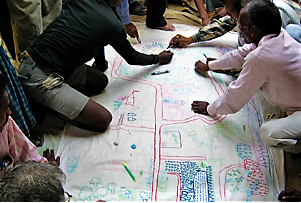
Community maps should be drawn by various members of the community in order to capture different perspectives and issues. Women, men, and children may identify different land use and resource issues. Also, people from different social status and background may have differing perspectives, ideas, and issues.
The more people participate in a mapping process, the more insights on the issue can be collected. However, one should keep in mind that an issue becomes more complex and the process of mapping becomes more time consuming, the more people are getting involved.
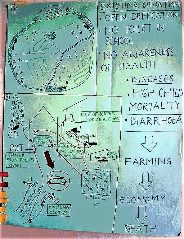
Steps for Participatory Mapping
Step 1. Ask the individual or the group to draw the boundaries of the geographic unit being discussed. Participants or the planner can decide how they want to represent this – on paper with writing or using local materials such as wet sand and earth with sticks, stones or seeds. Remember that whatever material is chosen, you will always need a paper-based copy to enable comparative analysis. If it adds to the discussion, three-dimensional elements can be added, transforming the map into a model that emphasises landscape-level aspects of issues. This base map can be multiplied and used for different contexts.
Step 2. On whatever medium is chosen, ask the participants to draw the outline of the local area, for example, roads, towns, rivers and property boundaries. One way to do this, if you have the proper resources, is to project an overhead map onto a large sheet of paper and then to trace the required information.
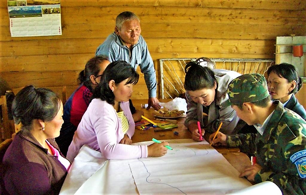
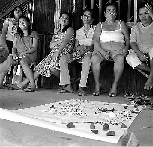
Step 3. Having prepared the map, which could be as large as a wall, people can then add their information either directly or by using sticky notes. Let them record what is most significant to them, and then ask for more detail if something you are interested in is missing. Motivate all the people present to add their perspective, without influencing them too much. (See also: facilitators role.)
To gain the most important information about the SSWM system of interest, use the following guiding questions and motivate people to add the missing information:
- Which are the problems (see situation and problem analysis category on Decision Making section) a community is confronted with (related to water or sanitation)?
- Where are these problems located?
- Where are the hotspots of these problems? Which are the worst?
- Potentially: Who is responsible for these problems?
- Are problems connected to each other? How do the problems influence each other?
- Are there good examples?
You can also orient yourself to the Understand your SSWM System chapter. This chapter explains which information should be included in the map and also questions how to ask for this information.
Step 4. Several modifications to the map may be needed before those involved are happy with the final result. Include additional written comments such as quantities of interest, if necessary.
Step 5. This map, representing the current state of affairs may be used later to make comparisons.
Participatory mapping is hence a very useful tool to get a first overview of where the largest problems and hotspots in regard to sustainable sanitation and water management are. It allows both local stakeholders and external planners to explore a current situation in a simple, but comprehensive way.
When Is Participatory Mapping Used?
Because every situation is different, it is not always clear when participatory mapping should be considered. Participatory mapping generally is not appropriate for minor decisions because the process can be time-consuming and requires significant planning.
More complex situations with far-reaching impacts, however, usually warrant some type of stakeholder involvement. Participatory mapping may be an option in these cases.
In the context of SSWM, consider using participatory mapping as a decision support instrument for the following situations:
- Visually displaying scenarios will enhance stakeholder understanding and awareness.
- Visually displaying alternative solutions will provide stakeholders with an opportunity to provide feedback.
- The process can enhance other stakeholder-engagement methods—for example, during a focus group to help visualise issues and resources and thereby stimulate discussion.
- The process will help develop solutions and alternatives generated by stakeholders.
- The maps can help fostering a more holistic or ecosystem approach by educating stakeholders about the issues and interrelationships of resources outside their immediate areas of concern (NOAA 2009).
- It allows an outsider (e.g. a planner, a consultant, an external expert etc.) to get a quick but comprehensive overview.
- It often makes sense to combine participatory mapping with other methods and tools supporting the decision making process such as: mind mapping, brain storming, rich picture, nominal groups, problem tree analysis etc.
Participatory Appraisal Techniques
Participatory Rural Appraisal in the Southern Gobi
The paper documents the research on implementing Participatory Rural Appraisals (PRAs) to investigate water related concerns and vegetation dynamics of herder and vegetable farmer communities in the southern Omnogovi aimag (‘province’) of Mongolia.
HAWKINS (2006): Participatory Rural Appraisal in the Southern Gobi. Not publishedGood Practices in Participatory Mapping
This report explores the power of participatory mapping. Covering a range of techniques, intermediaries, tools and impacts, it is shown how a systematic approach could contribute to addressing conflict-related issues and improving community ownership in sustainable environmental and natural resource management.
IFAD (2009): Good Practices in Participatory Mapping. Rome: International Fund for Agricultural Development (IFAD) URL [Accessed: 04.05.2010]Multi-Stakeholder Processes: Locality Mapping
This document by the MSP Resources Portal of the University of Wageningen, Centre for Development Innovation, gives a short but concise overview of locality mapping. The link http://portals.wi.wur.nl/msp/?page=1230 also describes other tools for multi-stakeholder processes.
MSP RESOURCE PORTAL (2009): Multi-Stakeholder Processes: Locality Mapping. Wageningen: Wageningen UR Centre for Development Innovation. [Accessed: 04.05.2010] PDFStakeholder Engagement Strategies for Participatory Mapping
This publication provides some simple strategies for facilitators leading a participatory mapping process. While there are many aspects of participatory mapping, the document focuses primarily on stakeholder involvement.
NOOA (2009): Stakeholder Engagement Strategies for Participatory Mapping. Charlston: National Oceanic and Atmospheric Administration (NOAA) URL [Accessed: 29.06.2019]Stakeholder Engagement Strategies for Participatory Mapping
This publication provides some simple strategies for facilitators leading a participatory mapping process. While there are many aspects of participatory mapping, the document focuses primarily on stakeholder involvement.
NOOA (2009): Stakeholder Engagement Strategies for Participatory Mapping. Charlston: National Oceanic and Atmospheric Administration (NOAA) URL [Accessed: 29.06.2019]Good Practices in Participatory Mapping
This report explores the power of participatory mapping. Covering a range of techniques, intermediaries, tools and impacts, it is shown how a systematic approach could contribute to addressing conflict-related issues and improving community ownership in sustainable environmental and natural resource management.
IFAD (2009): Good Practices in Participatory Mapping. Rome: International Fund for Agricultural Development (IFAD) URL [Accessed: 04.05.2010]The World Bank Participation Source Book
The World Bank understands participation as a process through which stakeholders influence and share control over development initiatives. The sourcebook shall help the reader to discover how this can be provided. Note that due to the large file size of this document, some pages were cropped.
WORLD BANK (1996): The World Bank Participation Source Book. (= Environmental Management Series ). Washington: World Bank URL [Accessed: 04.05.2010]Participation and Social Assessment: Tools and Techniques
This resource kit aims to share information and experiences on participatory methods in the context of development cooperation. The primary focus concentrates on providing practical guidance and case examples.
RIETBERGEN-McCRACKEN, J. NARAYAN, D. WORLD BANK (1998): Participation and Social Assessment: Tools and Techniques. Washington: World Bank URL [Accessed: 10.05.2010]Getting communities engaged in water and sanitation projects: participatory design and consumer feedback
Community engagement in water and sanitation service delivery is key for ensuring project sustainability and accountability. This Topic Brief looks at community engagement approaches used by WSUP in three cities within the African Cities for the Future (ACF) programme: Antananarivo (Madagascar), Kumasi (Ghana) and Maputo (Mozambique). The Topic Brief highlights some of the key challenges, and ends with practical recommendations for programme managers about how to engage low-income communities in the design of water supply and sanitation projects.
WSUP (2013): Getting communities engaged in water and sanitation projects: participatory design and consumer feedback. London: Water & Sanitation for the Urban Poor (WSUP) URL [Accessed: 30.06.2019]Participatory Rural Appraisal in the Southern Gobi
The paper documents the research on implementing Participatory Rural Appraisals (PRAs) to investigate water related concerns and vegetation dynamics of herder and vegetable farmer communities in the southern Omnogovi aimag (‘province’) of Mongolia.
HAWKINS (2006): Participatory Rural Appraisal in the Southern Gobi. Not publishedTools for Community Participation. A Manual for Training Trainers in Participatory Techniques
This manual focuses on one approach to participatory training which PROWESS has applied in numerous projects and workshops. Intended primarily for the training of trainers in participatory techniques, it describes these techniques in a "how to" step-by-step fashion. This manual is also intended to be a "discussion starter" and delves into some of the political issues underlying participation and the often conflicting priorities of communities and development practitioners.
SRINIVASAN, L. (1990): Tools for Community Participation. A Manual for Training Trainers in Participatory Techniques. New York: PROWESS/UNDP Technical Series