المُلخص التنفيذي
River water is an important surface water resource for households, agriculture (e.g. irrigation, animal husbandry) and industry (e.g. processing water and energy production). Moreover, rivers also provide many ecosystem services (e.g. tourism). River water quantity and quality strongly depends on its runoff system, the seasonal changes and the general soil and vegetation it flows through on its way to the sea. There are several methods to extract river water for use; some of them need skilled labour. To protect rivers, wastewater has to be treated before it is discharged into it.
| المُدخلات | المُخرَجات |
|---|---|
Freshwater, Drinking Water, Energy |
Introduction
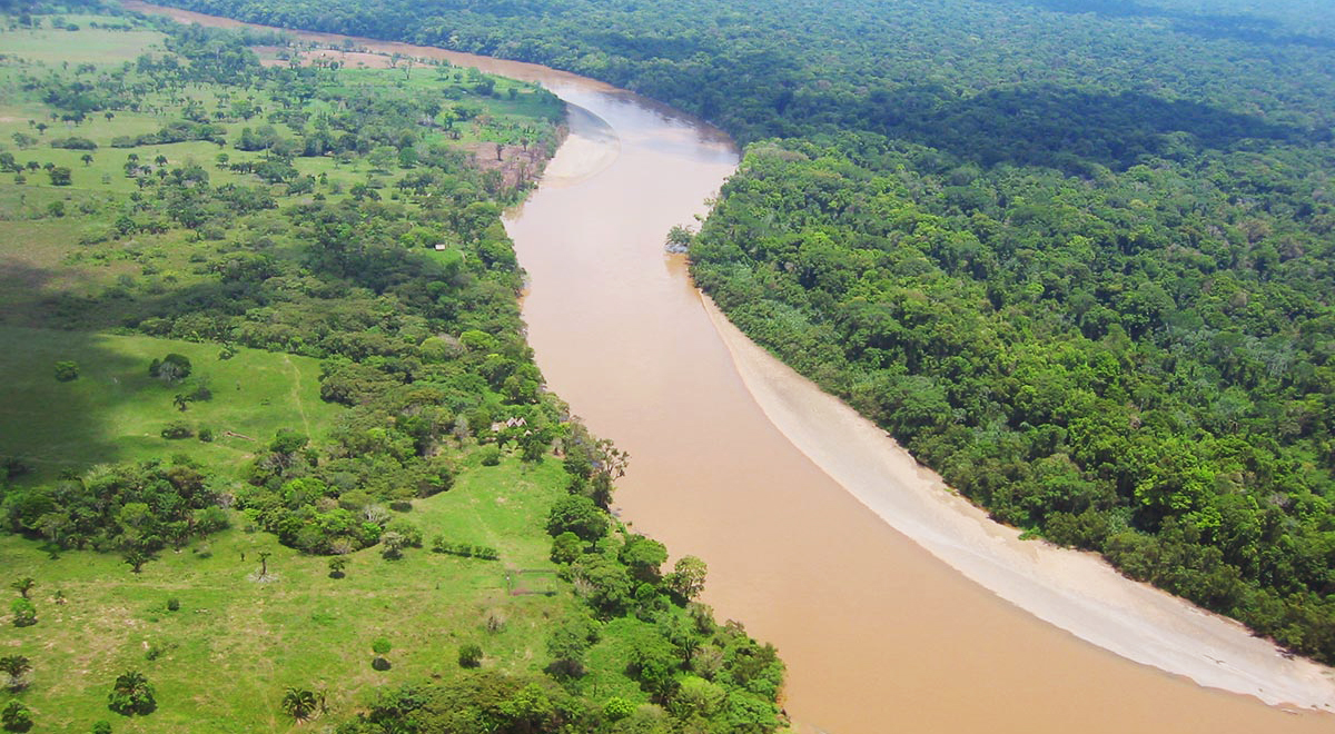
River water is a surface water source and a part of the water cycle. It can be used for households, irrigation, processing in industries or for the production of energy. Drinking water has to be handled and produced more carefully (see water purification) than irrigation water, because it can contain substances that endanger human health (see also water borne diseases and contaminants).
The quality and quantity of the water carried in the river depends on various factors. First of all, river water depends on the watershed. This means the river water level changes throughout the year with the different seasons. The seasons are closely linked to the different climatic regions and of course the river catchment. Large catchments influence the river water level more slowly than small catchments (FAO 1992). Strong slopes in the catchment area mean more surface run-off and thus more sediments and soil that are brought into the river.
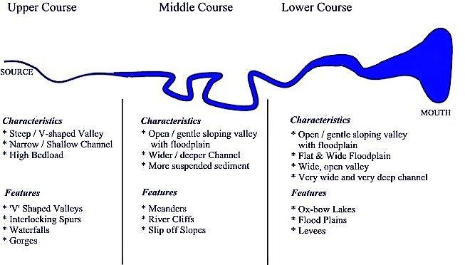
Simple river regimes have their runoff peak once, caused through rainfall or melting water from glaciers and snow. But when river catchment areas are covered by at least 15 to 20% of glaciers they have different regimes. They have their highest level in warm months (melt water) and the lowest in cold months. Totally different are tropical regimes, where the most important factor is the rainy and the dry season. The highest peaks can appear after the rainy season, when groundwater streams are added. Most river regimes react more complex, both because they are long and therefore part of different climatic regions, or the catchment areas are supplied by different factors, such as rain and glaciers (FAO 1992).
In dry regions, much of the water that falls as rain is used by the environment, so that any we extract or intercept may have an effect (NTA 2011).
Canals
Canals or water-channels are man-made mainly for two different purposes: carrying goods by boat, or irrigation for agriculture. Very famous canals for shipping goods are the Suez Canal in the middle East and the Panama Canal in Central America. In countries or regions where the climate is arid or where big volumes of water are used for irrigation, canals are built to guarantee constant water supply for agriculture. For example, the irrigation system of Punjab in Northern India secures water supply of monsoon fails (KRISHNA 2011). Channels are similar to rivers although the ecology and the flowing regime (e.g. turbulence) change significantly depending on the form and regularity of the riverbed.
River Shape, Floods and Flood Control
River Shape
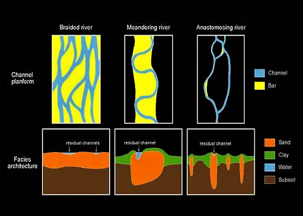
The development of a river channel consists of three stages: youthful, mature and old age (IMMOOR 2006). River patterns (fluvial styles) have been classified by LEOPOLD & WOLMAN (1957) as braided, meandering and straight. This classification is essentially based on the shape of the river channel, as it appears on aerial photographs. Later, SMITH (1983) added anastomosed rivers as a distinct fluvial style (UU 2007).
Often, in urbanised areas, rivers are corrected in order to regain land. Corrected rivers flow through a straight constructed bed, avoiding meandering or braiding.
Floods
Adapted from IWA WATER WIKI 2009
Periodic floods occur on many rivers, creating a surrounding area known as the flood plain. During rain- or snowfall, some of the precipitation is retained in lakes and ponds, man-made reservoirs, riverbeds, ponds or soil; some is absorbed by grass and vegetation, some evaporates, and the rest travels over land as surface runoff. Floods occur when these natural and constructed reservoirs cannot absorb all the water and the surface runoff is drastically increased. About 30% of all precipitation ends as runoff. The amount of runoff can be increased from snowmelt. River flooding is often caused by heavy rain, sometimes increased by snowmelt.
A flood that rises rapidly, with little or no advance warning, is called a flash flood. Flash floods usually result from intense rainfall over a relatively small area, or if the area was already saturated from previous precipitation.
Flood Control
Some methods of flood control have been practised since ancient times. These methods include planting vegetation to retain extra water, terracing hillsides to slow flow downhill, and the construction of floodways (man-made channels to divert floodwater). Other techniques include the construction of dikes, dams, reservoirs or retention ponds to hold extra water during times of flooding.
In many countries, rivers prone to floods are often carefully managed. Defences such as dikes, bunds, reservoirs, and weirs are used to prevent rivers from bursting their banks. When these defences fail, emergency measures such as sandbags or portable inflatable tubes are used. Coastal flooding has been addressed in Europe and the Americas with coastal defences, such as sea walls, beach nourishment, and barrier islands.
Dikes are other methods of flood control. Compared to other methods, dikes considerably lower the risk of having floods.They can help prevent damage; however it is better to combine dikes with other flood control methods to reduce the risk of a collapsed dike.
Corrected rivers flowing through a straight constructed bed often lack areas and vegetation that help buffer floods, and floods might be more frequent or more intense.
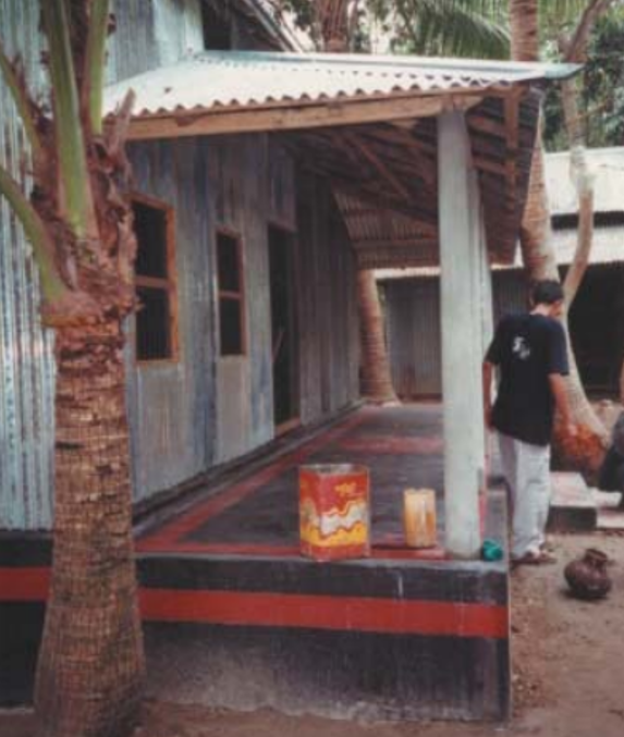
The construction of houses or communities in flood prone areas should be avoided. If done nevertheless, building designs must be adapted to the situation (see
Water Extraction
Water for household use or small scale irrigation can be extracted and distributed by buckets or pumped into water trucks to transport bigger amounts of water. Before it is used as drinking water it should be purified and tested. Water can also be pumped into a distribution network. To extract large amounts of water for cities (drinking water), agriculture (e.g. spate irrigation or surface irrigation, industrial use or hydropower), permanent water intakes or canals are necessary.
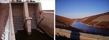
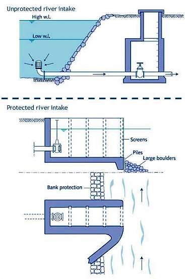
Whenever possible, a river intake should be situated (SMET and WIJK 2002):
- where there is adequate flow
- at a level that allows gravity supply to minimise pumping costs
- upstream of densely populated and farming areas to reduce silt inflow
- upstream of cattle watering places, washing places and sewer outlets (to eliminate pollution of the water)
- upstream of bridges (to reduce velocity/turbulence)
Intake designs aim at avoiding clogging and scouring and ensure the stability of the structure even under flood conditions. Where the river transports no boulders or rolling stones, an unprotected intake may be adequate.
Another way of abstracting drinking water is bank filtration. Bank filtration is a particularly environmentally friendly drinking water treatment technique that avoids the use of chemicals and combines, usually quite effectively, particle removal and pollutant breakdown (the latter by microorganisms in the sediment). Bank filtration describes the process during which surface water is infiltrated due to a natural hydraulic gradient or due to a depression cone caused by an abstraction well.
Impact on Environment
Extraction
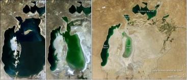
In order to minimise the impact of water extraction on environment, it is necessary to recognise the need to retain water for the environment. Managing water use causes some unique problems. Because water flows through the landscape, the effects of using water in one place can have effects in another place far away. Also, while one bore, pump or farm dam may not have a detectable impact, the cumulative effect of dozens of these across a catchment may have a very large effect. A typical example is the Aral Sea (see BARGHOUTI 2006). These problems emphasise the need of a sustainable approach for planning and implementing water management (see also IWRM and linking up sustainable sanitation and water management). Most of the problems of water extraction relate to the proportion of the total available water that is used (see also water resources assessment, water allocation and water balance estimation). If this proportion is kept within reasonable limits, both at local and catchment scales, the impacts will be minor and acceptable. There are also some principles that should be noted when planning to extract water from the environment (NRETAS 2007):
- Experience around the world confirms that dams on main river channels are often harmful to the environment.
- The use of precipitation water where it occurred (e.g. on a farm) is likely to have less impact than importing it.
- Off-stream storage of wet-season flow probably has the least impact of the methods for water capture.
- When water is not wasted, there is less chance of impact on water dependant wildlife, of soil salinity and of pollution of waterways.
Pollution and Eutrophication
An estimated 90% of all wastewater in developing countries is discharged untreated directly into rivers, lakes or the oceans. Such discharges are part of the reason why de-oxygenated dead zones and eutrophication are growing rapidly in the seas and oceans (CORCORAN et al. 2010) (see also water pollution and check out the paragraph on eutrophication in the lakes factsheet).
Sediment Transport
Soil erosion is a natural process accelerated by human activities (see also soil degradation). Much of this sediment moves into the river system, posing problems for river management and control. By assimilating nutrients and contaminants, sediment has serious implications both in rivers and coastal waters. Many of world’s rivers can be expected to show evidence of changing sediment loads in response to recent land-use change. The net effect of these changes on the global land-ocean sediment flux suggests that the ‘natural’ or ‘pre-human’ flux has been almost doubled by anthropogenic impacts. River sediment is not only the major water pollutant by weight and volume but also serves as a catalyst, carrier and storage agent for other forms of pollution. Usually, the greater the sediment concentration, the poorer the water quality. Sediment alone degrades water especially for urban supply, recreation, industrial consumption and cooling, hydroelectric facilities, and aquatic life (ZHIDE & YULING n.y.).
Conflicts
Although essential for human survival, water is rarely evenly distributed among populations. Local users compete to obtain their share, which can intensify existing tensions and sometimes lead to violence where the supply of water does not meet needs. Water availability is one of the major constraints on economic development, particularly for developing countries, because lack of water limits food production and economic activities such as industry and commerce (MBONILE 2005). Read more about water conflicts and water allocation.
Health Aspects
No potentially hazardous substances should be channelled into lakes, because the ecosystem services could be negatively influenced through water pollution (see also waterborne diseases and water source and well protection). Wastewater treatment before discharge into rivers and water treatment before further use are to be ensured.
River water as a surface water source is applicable for various uses. Availability of river water strongly depends on the needs of the local system. It is especially available in riparian regions with a regular runoff throughout the year. Proper management and regulation of water extraction is important to protect the ecosystem and to avoid user conflicts.
Case Study of the Aral Sea Water and Environmental Management Project
This review discusses the dire conditions of the Aral Sea, which has seen its surface area decline by two-thirds since 1960. The Aral Sea Water and Environmental Management Project was designed to help the countries in the area solve the environmental crises.
BARGHOUTI, S. (2006): Case Study of the Aral Sea Water and Environmental Management Project. Geneva: World Health Organisation (WHO) URL [Accessed: 13.12.2011] PDFSick Water? The central role of wastewater management in sustainable development
This book not only identifies the threats to human and ecological health that water pollution has and highlights the consequences of inaction, but also presents opportunities, where appropriate policy and management responses over the short and longer term can trigger employment, support livelihoods, boost public and ecosystem health and contribute to more intelligent water management.
CORCORAN, E. ; NELLEMANN, C. ; BAKER, E. ; BOS, R. ; OSBORN, D. ; SAVELLI, H. (2010): Sick Water? The central role of wastewater management in sustainable development. A Rapid Response Assessment. United Nations Environment Programme (UNEP), UN-HABITAT, GRID-Arendal URL [Accessed: 05.05.2010] PDFIrrigation Water Management: Training Manual No. 6 - Scheme Irrigation Water Needs and Supply
This training material gives an introduction to crop water needs and discusses the influence of climate, crop type and growth stage. It also discusses how much of the crop water need can be met by rainfall and/or irrigation applications. Further, it introduces the special requirements of growing rice. Finally, it looks at the irrigation water needs within a parcel of land at the plant level.
FAO (1992): Irrigation Water Management: Training Manual No. 6 - Scheme Irrigation Water Needs and Supply. Rome: Food and Agriculture Organization (FAO) URL [Accessed: 13.12.2011]Classification Rivers – Three Stages of River Development
This document describes the three different classifications for rivers: youthful, mature, and old. Each type is described in terms of its characteristics, sediment transport, and river velocity, and terminology.
IMMOR, L. (2006): Classification Rivers – Three Stages of River Development. Geotech.com URL [Accessed: 30.04.2012] PDFFlood Control and Disaster Management
Aral Sea 1989 and 2003
Water Extraction
To avoid the degradation of waterways as seen in southern Australia, it is necessary to plan water use carefully, and leave a large proportion of the water in the environment. Read more about in this factsheet edited by the Northern Territory Government.
NRETAS (2007): Water Extraction. Darwin: Northern Territory Government of Australia (NTA) PDFReservas de agua para el medio ambiente en México
Small Community Water Supplies: Technology, People and Partnership: Surface Water - Chapter 11
This book provides a general introduction to a wide range of technologies. Among the topics covered are: planning and management of small water supplies, community water supplies in Central and Eastern European countries, water quality and quantity, integrated water resources management, artificial recharge, rainwater harvesting, spring water tapping, groundwater withdrawal, water lifting, surface water intake, water treatment, aeration, coagulation and flocculation, sedimentation, multi-stage filtration, desalination technology, disinfection, household level water treatment, technologies for arsenic and iron removal from ground water, and emergency and disaster water supply. Chapter 11: Surface Water
SMET, J. ; WIJK, C. van (2002): Small Community Water Supplies: Technology, People and Partnership: Surface Water - Chapter 11. The Hague: International Water and Sanitation Centre (IRC) URL [Accessed: 29.02.2012] PDFAnastomosed Fluvial Deposits: Modern Examples from Western Canada
Aral Sea 2011
Fluvial style
River Flood Plains: Some Observations on their Formation
The Hydrosphere: WordPress Weblo
Sediment in Rivers –Origin and Challenges
Soil erosion is a natural process accelerated by human activities. Each year, erosion of surface soil from river basins amounts to 60 billion tons, resulting in 24 billion tons of sediment flux to the oceans and almost 25 billion tons of soil lost from agricultural land. From a global point of view, this represents a redistribution of soil resources by about 7 per cent each decade with multiple consequences. Much of this sediment moves into river systems, posing many problems for river management and control. By assimilating nutrients and contaminants, sediment has serious implications both in rivers and coastal waters.
ZHIDE, Z. YULING, T. (n.y): Sediment in Rivers –Origin and Challenges. Beijing: The International Research and Training Center on Erosion and Sedimentation URL [Accessed: 19.04.2012] PDFSick Water? The central role of wastewater management in sustainable development
This book not only identifies the threats to human and ecological health that water pollution has and highlights the consequences of inaction, but also presents opportunities, where appropriate policy and management responses over the short and longer term can trigger employment, support livelihoods, boost public and ecosystem health and contribute to more intelligent water management.
CORCORAN, E. ; NELLEMANN, C. ; BAKER, E. ; BOS, R. ; OSBORN, D. ; SAVELLI, H. (2010): Sick Water? The central role of wastewater management in sustainable development. A Rapid Response Assessment. United Nations Environment Programme (UNEP), UN-HABITAT, GRID-Arendal URL [Accessed: 05.05.2010] PDFClassification Rivers – Three Stages of River Development
This document describes the three different classifications for rivers: youthful, mature, and old. Each type is described in terms of its characteristics, sediment transport, and river velocity, and terminology.
IMMOR, L. (2006): Classification Rivers – Three Stages of River Development. Geotech.com URL [Accessed: 30.04.2012] PDFRiver And Stream Ecosystems
Rivers provide many critical goods and services, including drinking water, power generation, nutrient recycling, organic matter retention, habitat for many unique plants and animals and recreational activities. Rivers in the northern Great Lakes region have a rich history, and the roles they play are reflected in the land use and vegetation associated with that region.
JOHNSON, L. HAYHOE, K. KLING, G. MAGNUSON, J. SHUTER, B. (2003): River And Stream Ecosystems. Cambridge: Union of Concerned Scientists USA (UCSUSA) URL [Accessed: 15.12.2011] PDFWater Extraction
To avoid the degradation of waterways as seen in southern Australia, it is necessary to plan water use carefully, and leave a large proportion of the water in the environment. Read more about in this factsheet edited by the Northern Territory Government.
NRETAS (2007): Water Extraction. Darwin: Northern Territory Government of Australia (NTA) PDFSmall Community Water Supplies: Technology, People and Partnership: Surface Water - Chapter 11
This book provides a general introduction to a wide range of technologies. Among the topics covered are: planning and management of small water supplies, community water supplies in Central and Eastern European countries, water quality and quantity, integrated water resources management, artificial recharge, rainwater harvesting, spring water tapping, groundwater withdrawal, water lifting, surface water intake, water treatment, aeration, coagulation and flocculation, sedimentation, multi-stage filtration, desalination technology, disinfection, household level water treatment, technologies for arsenic and iron removal from ground water, and emergency and disaster water supply. Chapter 11: Surface Water
SMET, J. ; WIJK, C. van (2002): Small Community Water Supplies: Technology, People and Partnership: Surface Water - Chapter 11. The Hague: International Water and Sanitation Centre (IRC) URL [Accessed: 29.02.2012] PDFWater, Drinking Water, and Water Protection. Drinking Water Treatment
This article written by the department of environment of the German government is about water, drinking water and water protection.
UBA (2011): Water, Drinking Water, and Water Protection. Drinking Water Treatment. Dessau-Rosslau: Umweltbundesamt PDFSediment in Rivers –Origin and Challenges
Soil erosion is a natural process accelerated by human activities. Each year, erosion of surface soil from river basins amounts to 60 billion tons, resulting in 24 billion tons of sediment flux to the oceans and almost 25 billion tons of soil lost from agricultural land. From a global point of view, this represents a redistribution of soil resources by about 7 per cent each decade with multiple consequences. Much of this sediment moves into river systems, posing many problems for river management and control. By assimilating nutrients and contaminants, sediment has serious implications both in rivers and coastal waters.
ZHIDE, Z. YULING, T. (n.y): Sediment in Rivers –Origin and Challenges. Beijing: The International Research and Training Center on Erosion and Sedimentation URL [Accessed: 19.04.2012] PDFCase Study of the Aral Sea Water and Environmental Management Project
This review discusses the dire conditions of the Aral Sea, which has seen its surface area decline by two-thirds since 1960. The Aral Sea Water and Environmental Management Project was designed to help the countries in the area solve the environmental crises.
BARGHOUTI, S. (2006): Case Study of the Aral Sea Water and Environmental Management Project. Geneva: World Health Organisation (WHO) URL [Accessed: 13.12.2011] PDFBow River Basin State of the Watershed Summary 2010
This “State of Summary” booklet about the Bow River basin is a great example about a river system and its benefits. This booklet in particular and the WSOW (Web-based State of the Watershed) tool is intended to help water managers and users better understand the state of the Bow River watershed.
BOW RIVER BASIN COUNCIL (2010): Bow River Basin State of the Watershed Summary 2010. Calgary: Bow River Basin Council - Calgary Water Centre URL [Accessed: 30.04.2012] PDFPopulation, Migration, and Water Conflicts in the Pangani River Basin, Tanzania
Many conditions may trigger conflicts, including jurisdictional ambiguities, miscommunication, and competition between sectors and users. This article describes how population growth and migration in Tanzania’s Pangani River basin—arguably the most waterstressed basin in the country—have intensified local water conflicts. Resolving these conflicts requires understanding the socio-cultural context of the local communities and increasing stakeholder involvement in water management.
MBONILE, M.J. (2005): Population, Migration, and Water Conflicts in the Pangani River Basin, Tanzania. المُدخلات: REPORT FROM AFRICA: Population, Health, Environment, and Conflict: Volume 12 , 20-28. URL [Accessed: 19.04.2012]Law, International Water
This online article talks about the water as a potential source for conflicts and the international law for international waters. Furthermore it contains a case study about the Nile River.
Dams
Dams have several benefits. They can be constructed to obstruct or control the flow of water in rivers and streams, to create a lake/ reservoir upstream of the river or to generate electricity.
Pollution of Streams by Garbage and Trash
Despite environmental regulations that protect the quality of streams, lakes, and wetlands, solid waste in the form of trash, litter, and garbage often ends up in these surface waters. Read more about it online.
Rivers Network
This open-source platform has dedicated itself to spread knowledge and awareness about the river basins of the world. It provides geographically specific information as a basis for improving sustainable management of rivers.
