Resumen ejecutivo
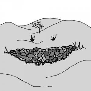
Gully plugs, also called check dams, are mainly built to prevent erosion and to settle sediments and pollutants. Furthermore, it is possible to keep soil moisture due to infiltration. Depending on the topography, amount of precipitation, material and financial resources available, there are several methods to construct a gully plug. They have to be inspected regularly and any damages must be repaired.
| Entradas | Salidas |
|---|---|
Freshwater |
Introduction
A check dam (also called gully plug) is a small, temporary or permanent dam constructed across a drainage ditch, swale, or channel to lower the speed of concentrated flows for a certain design range of storm events. A check dam can be built from wood logs, stone, pea gravel-filled sandbags or bricks and cement (RUFFINO 2009). Reduced runoff speed reduces erosion and gully erosion in the channel and allows sediments and other pollutants to settle out. Check dams are inexpensive and easy to install. They may be permanent if designed properly and can be used where it is not possible to otherwise divert flow and stabilise the channel (POLYTECHNIC n.y.). Furthermore, they allow groundwater recharge (RUFFINO 2009). While gully plugs are able to retain soil moisture, to harvest runoff water, sand dams (which are similar in appearance) might be the better solution.
Basic design principles
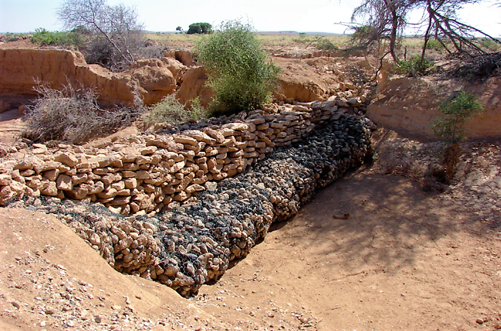
The size and shape of a drainage area, as well as the length and gradient of its slopes, have an effect on the run-off rate and amount of surface water. Therefore, all topographic characteristics should be studied in detail before gully-plugging work begins. There are several designs for how check dams should be constructed. The kind of gully plug that should be constructed depends on the local situation (what kind of material is available, slope gradient, is it a permanent solution, what tasks are intended). In gully control, temporary structural measures such as woven-wire, brushwood, logs, loose stone and boulder check dams are used to facilitate the growth of permanent vegetative cover. Check dams are constructed across the gully bed to stop, as already described, channel and lateral erosion. By reducing the original gradient of the gully channel, check dams diminish the velocity of water flow and the erosive power of run-off. Run-off during peak flow is conveyed safely by check dams. Temporary check dams, which have a life span of three to eight years, collect and hold soil and moisture in the bottom of the gully. Tree seedlings, as well as shrub and grass cuttings planted in gullies, can grow without being washed away by flowing water. Thus, a permanent vegetative cover can be established in a short time (FAO 1986).
General construction guidelines
(adapted from AKVOPEDIA 2012)
- The sides of the check dam must be higher than the centre so that water is always directed over the centre of the dam (this avoids the dam being outflanked by the flow).
- The dam can be made of temporary or permanent materials in natural gullies on the land surface. Materials used are concrete, earth, vegetation, stone and brushwood. Where earth is used, erosion or destruction of the structure needs to be avoided – to do this, a concrete spillway is often constructed. As they use the existing drainage system, no design of trench is needed (as with contour trenches).
- Do not construct check dams in watercourses or permanently flowing streams without specific design (because of possible restrictions to fish passage).
Specific treatments
In the following section, several check dam methods are introduced (FAO 1986):
Brush fills
Brush fill is a continuous filling of small gullies with brush, branches of trees, stems of bushy vegetation, etc. This method is also called brush plug and is especially economical where brush is plentiful.
Earth plugs
Earth plugs, which are small structures, are constructed across the gullies. Their main purpose is to hold water and let it percolate into the ground (see also surface groundwater recharge). In non-humid regions, small gullies which are not deeper than 2 metres, with a gully bed gradient of less than 10 per cent, can be stabilised by a series of earth plugs. In humid regions, earth plugs must be combined with small diversions. Distribution of earth plugs depends on the gully channel's gradient.
Woven-wire check dams
Woven-wire check dams are small barriers which are usually constructed to hold fine material in the gully. They are used in gullies with moderate slopes (not more than 10 per cent) and small drainage areas that do not have flood flows which carry rocks and boulders.
Brushwood check dams
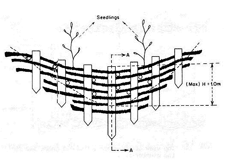
Brushwood check dams made of posts and brush are placed across the gully. The main objective of brushwood check dams is to hold fine material carried by flowing water in the gully. Small gully heads, no deeper than one metre, can also be stabilised by brushwood check dams. Brushwood check dams are temporary structures and should not be used to treat ongoing problems such as concentrated run-off from roads or cultivated fields. They can be employed in connection with land use changes such as reforestation or improved range management until vegetative and slope treatment measures become effective.
Log check dam
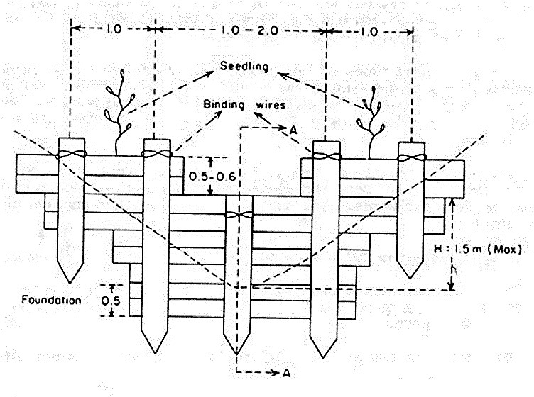
Log check dams made of logs and posts are placed across the gully. They can also be built of planks, heavy boards, slabs, poles or old railroad ties. The main objectives of log check dams are to hold fine and coarse material carried by flowing water in the gully, and to stabilise gully heads. They are used to stabilise incipient, small and branch gullies generally not longer than 100 metre and with catchment areas of less than two hectares. The maximum height of the dam is 1.5 metres from the ground level. Both its downstream and upstream face inclination is 25 per cent backwards. Its spillway form is rectangular. In general, the length and depth of its spillway are one to two metres and 0.5 to 0.6 metres.
Loose stone check dams
Loose stone check dams made of relatively small rocks are placed across the gully. The main objectives for these dams are to control channel erosion along the gully bed and to stop waterfall erosion by stabilising gully heads. Loose stone check dams are used to stabilise the incipient and small gullies and the branch gullies of a continuous gully or gully network. The length of the gully channel is not more than 100 metres and the gully catchment area is two hectares or less. These dams can be used in all regions.
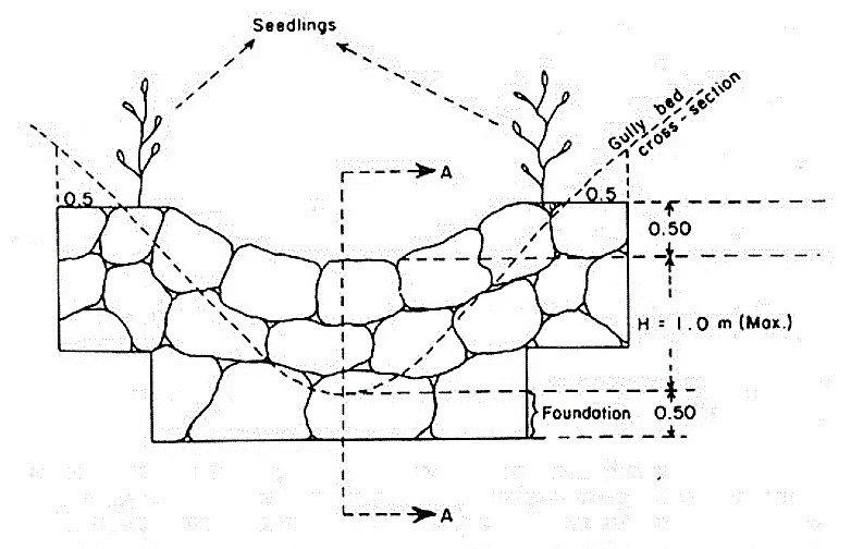
Cost considerations
The cost in India is reported to be between US $200-400 for temporary dams (made from brush wood, rocks, soil) and US $1,000- 3,000 for permanent dams (made from stones, bricks, cement), depending on the length and height. Variation depends on materials used and size of gully (AKVOPEDIA 2012). To stop gully erosion, early interventions are far more economical than late ones. A small gully or rill can be repaired with basic gully plugs (e.g. brush fills) (FAO 1986).
Operation and maintenance
Check dams should be inspected regularly for sediment accumulation after each significant rainfall. Sediment should be removed when it reaches one-half of the original height or before. Check to ensure that the flow is over the centre of the dam and not either under or around the dam. Check that there is no erosion at the outfall (AKVOPEDIA 2012).
At a glance
| Working principle | A check dam (or also called gully plug) is a small, temporary or permanent dam constructed across a drainage ditch, swale, or channel to lower the speed of concentrated flows for a certain design range of storm events and to conserve soil moisture. |
| Capacity/adequacy | Vegetation cover and gully plugs are used by farmers facing soil loss, probably in regions with slope on the fields. |
| Performance | High performance: vegetation patterns change runoff peaks and prevent soil loss. |
| Costs | Small dams do not cost much, but work is required. Bigger and permanent constructions are expensive. |
| Self-help compatibility | Small plugs can be self-constructed with local available material. Even though it is more or less easy to build some knowledge about precipitation, run-off and topography is required. |
| O&M | Vegetation and plugs have to be controlled several times a year to prevent/repair damages. |
| Reliability | A reliable method to minimise soil loss. |
| Main strength | Water speed is slowed down and infiltrated into the soil. Prevents (gully) erosion. |
| Main weakness | When only focussing on gully plug construction, the main cause of gully development is missed. |
This method allows farmers to protect themselves against soil loss problems from runoff. It slows down the runoff velocity on sloped land, helps to settle out sediments, and helps to retain soil moisture (learn more about soil moisture conservation). Some expert knowledge is required to adapt the correct check dam (depending on topography, precipitation, material).
FAO Watershed Management Field Manual. Gully Control
The purpose of this document is to provide practical guidance for gully control including a description of the factors affecting gully formation and a classification of gullies. Control measures include diversions and the specifications for various types of check dams and gully plugs.
FAO (1986): FAO Watershed Management Field Manual. Gully Control. Rome: Food and Agriculture Organisation of the United Nations (FAO) URL [Visita: 09.05.2012]Technical Manual. Integrated Watershed Management Programme (IWMP)
The appropriate design and proper selection of site is very important for ridge to valley treatment. This manual (only online available as an open source document) gives systematically ridge to valley treatment with details engineering activities with appropriate design, drawings, estimation example and photograph of each structure.
GSWMA (2011): Technical Manual. Integrated Watershed Management Programme (IWMP). Gandhingar: Gujarat State Watershed Management Agency (GSWMA) URL [Visita: 08.05.2012]Green Water Management Handbook. Rainwater Harvesting for Agricultural Production and Ecological Sustainability
This handbook highlights the principles and technologies that can be used to harness the huge untapped potential of rainwater. Instead of a stereotyped view focusing only on rivers and groundwater, the book directs readers in recognising rain as the ultimate source of water for food production and other uses in rural economies across Africa.
MALESU, M.M. ; ODUOR, A.R. ; ODHIAMBO, O.J. (2007): Green Water Management Handbook. Rainwater Harvesting for Agricultural Production and Ecological Sustainability. Nairobi: The World Agroforestry Centre URL [Visita: 13.03.2019] PDFCheck Dam
What is it? A check dam is a small, temporary or permanent dam constructed across a drainage ditch, swale, or channel to lower the speed of concentrated flows for a certain design range of storm events.
POLYTECHNIC (n.y): Check Dam. Windhoek: Polytechnic of Namibia. [Accessed: 08.05.2012] PDFRainwater Harvesting and Artificial Recharge to Groundwater
This document provides a review of major technologies used in rainwater harvesting.
RUFFINO, L. (2009): Rainwater Harvesting and Artificial Recharge to Groundwater. Brussels: SAI Platform URL [Visita: 09.05.2012]Check Dams
A short description of check dams appeared in the California Stormwater BMP Handbook.
CASQA (2003): Check Dams. Menlo Park: Californian Stormwater Quality Association URL [Visita: 09.07.2019]FAO Watershed Management Field Manual. Gully Control
The purpose of this document is to provide practical guidance for gully control including a description of the factors affecting gully formation and a classification of gullies. Control measures include diversions and the specifications for various types of check dams and gully plugs.
FAO (1986): FAO Watershed Management Field Manual. Gully Control. Rome: Food and Agriculture Organisation of the United Nations (FAO) URL [Visita: 09.05.2012]Water Harvesting for Upgrading of Rainfed Agriculture
The report is mainly divided into three parts. The first part presents the hydro-climatic constraints and challenges facing farmers, and gives a brief presentation of water harvesting and farmers coping strategies to manage water scarcity. In the second part of the report regional approaches from sub-Saharan Africa, India and China are presented. Based on the financial support available and the possibility to obtain information from literature, it was decided to base the India chapter on literature and the China chapter on a short study visit to Gansu and Hebei provinces. The sub-Saharan Africa chapter gives a comprehensive description of water harvesting experiences with emphasis on floodwater harvesting and storage systems supplementary irrigation. The last part of the report reflects knowledge gaps that need to be filled, regarding both technical -, process – and systems research.
FALKENMARK, M. FOX, P. PERSSON, G. ROCKSTROM, J. (2001): Water Harvesting for Upgrading of Rainfed Agriculture. Stockholm: Stockholm International Water Institute URL [Visita: 09.07.2019]Technical Manual. Integrated Watershed Management Programme (IWMP)
The appropriate design and proper selection of site is very important for ridge to valley treatment. This manual (only online available as an open source document) gives systematically ridge to valley treatment with details engineering activities with appropriate design, drawings, estimation example and photograph of each structure.
GSWMA (2011): Technical Manual. Integrated Watershed Management Programme (IWMP). Gandhingar: Gujarat State Watershed Management Agency (GSWMA) URL [Visita: 08.05.2012]Erosion and Sediment Control. Check Dams
This short chapter describes purpose, construction and maintenance of check dams and includes some technical drawings.
HAWKES BAY (2009): Erosion and Sediment Control. Check Dams. Napier: Hawkes’s Bay Regional Council URL [Visita: 09.07.2019]Wet Watershed Management Guide. Water Harvesting and Soil Conservation in High Rainfall Areas
This guide discusses the process and type of interventions that come with wet watershed management or wet water harvesting and soil conservation in plain high rainfall areas. The guide is based on wet watershed management, as it is time-tested in the North Bengal Terai Region of India.
MAHAPATRA, N. (n.y): Wet Watershed Management Guide. Water Harvesting and Soil Conservation in High Rainfall Areas. West Bengal: Centre for the Development of Human Initiatives (CDHI) URL [Visita: 08.05.2012]Green Water Management Handbook. Rainwater Harvesting for Agricultural Production and Ecological Sustainability
This handbook highlights the principles and technologies that can be used to harness the huge untapped potential of rainwater. Instead of a stereotyped view focusing only on rivers and groundwater, the book directs readers in recognising rain as the ultimate source of water for food production and other uses in rural economies across Africa.
MALESU, M.M. ; ODUOR, A.R. ; ODHIAMBO, O.J. (2007): Green Water Management Handbook. Rainwater Harvesting for Agricultural Production and Ecological Sustainability. Nairobi: The World Agroforestry Centre URL [Visita: 13.03.2019] PDFSediment Control. Check Dams
This paper describes how check dams help to control sedimentation.
METROPOLITAN COUNCIL (n.y): Sediment Control. Check Dams. St. Paul: Metropolitan Council URL [Visita: 09.07.2019]Soil Erosion Control - Mulches, Blankets and Mats
These practices involve the application of organic materials to form a temporary, protective soil cover. They can be implemented as a pre-made blanket or applied loose as a mulch. Organic mulches, hydraulically applied mulches, erosion control blankets and turf-reinforcement mats (TRMs) are discussed in this paper. When selected and applied correctly, they are the most effective, practical means of controlling runoff and erosion on disturbed land prior to vegetation establishment.
METROPOLITAN COUNCIL (n.y): Soil Erosion Control - Mulches, Blankets and Mats. St. Paul: Metropolitan Council URL [Visita: 09.07.2019]Check Dam
What is it? A check dam is a small, temporary or permanent dam constructed across a drainage ditch, swale, or channel to lower the speed of concentrated flows for a certain design range of storm events.
POLYTECHNIC (n.y): Check Dam. Windhoek: Polytechnic of Namibia. [Accessed: 08.05.2012] PDFRainwater Harvesting and Artificial Recharge to Groundwater
This document provides a review of major technologies used in rainwater harvesting.
RUFFINO, L. (2009): Rainwater Harvesting and Artificial Recharge to Groundwater. Brussels: SAI Platform URL [Visita: 09.05.2012]Gullies and their Control
This technical document describes the formation and control of gullies. The severity of gully development depends on a number of factors including soil type, vegetation, rainfall, concentrated flow, and human disturbances. Gullies can erode hillslopes and fill stream channels with sediment. Unchecked, they erode and deliver sediment through a variety of processes that cause loss in soil productivity, channel entrenchment, and headward expansion into the landscape. To best select a design alternative, the desired results of the landowner must be understood along with the character of the gully and its potential impacts.
USACE (2007): Gullies and their Control. New Concord: US Army Corps of Engineers (USACE) URL [Visita: 09.07.2019]Water Harvesting
Water harvesting has been practiced successfully for millennia in parts of the world – and some recent interventions have also had significant local impact. Yet water harvesting’s potential remains largely unknown, unacknowledged and unappreciated. These guidelines cover a wide span of technologies from large-scale floodwater spreading to practices that collect and store water from household compounds.
MEKDASCHI STUDER, R. LINIGER, H. (2013): Water Harvesting. Guidelines to Good Practice. Bern/Amsterdam/Wageningen/Rome: Centre for Development and Environment (CDE), Rainwater Harvesting Implementation Network (RAIN), MetaMeta, The International Fund for Agricultural Development (IFAD) URL [Visita: 12.03.2019] PDFEffectiveness of Contour Bunds and Gully Plugs as Tool for Watershed Treatment. A Case Study of Khabji Village of Bharuch District
A case study about contour bunds and gully plugs.
KHANNA, S. (1997): Effectiveness of Contour Bunds and Gully Plugs as Tool for Watershed Treatment. A Case Study of Khabji Village of Bharuch District. URL [Visita: 09.05.2012]Check dams (gully plugs)
This short description about check dams concludes all important facts.

